
Lidaretto H32S(X) Professional Long-Range SLAM Scanner
Price Available Upon Request
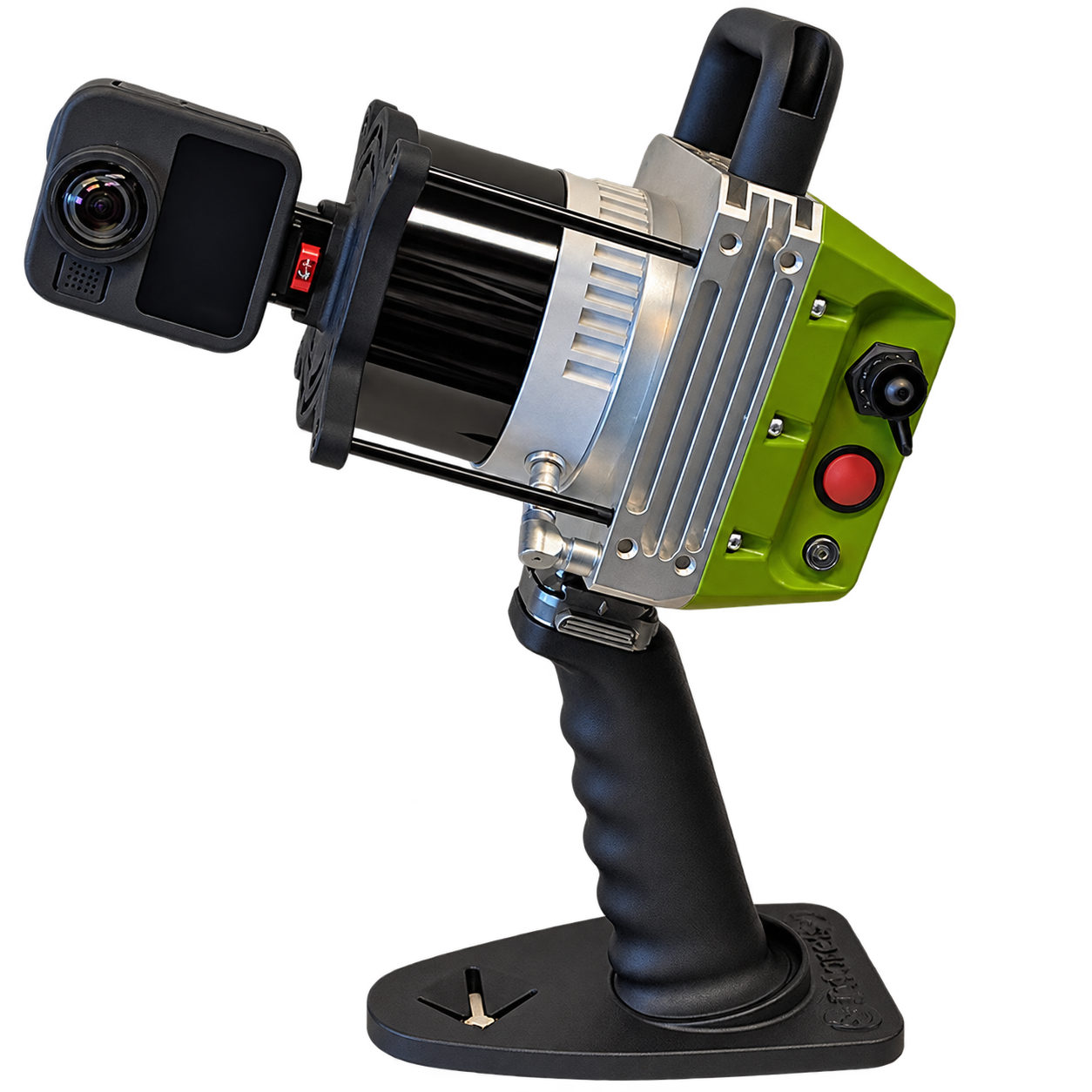
The Lidaretto H32S(X) is a professional SLAM scanning system for indoor and outdoor 3D data capture, combining a 32-channel Hesai LiDAR, high-performance IMU, ±1 cm range accuracy, up to 640,000 points/sec, 1 TB internal memory, and a detachable 8K 360° camera. Available as the H32S with up to 120 m range or the H32SX with up to 300 m range, it operates without requiring GNSS and supports handheld, harness, and backpack scanning.
Product Overview
The Lidaretto H32S(X) is a professional long-range SLAM scanning system designed for indoor and outdoor 3D data capture.
The system combines a Hesai XT32 or XT32M2X LiDAR sensor with a high-performance integrated IMU in a compact unit and supports a detachable 8K 360° camera for point-cloud colorization and panoramic image export.
The H32S(X) operates using SLAM (Simultaneous Localization and Mapping) and does not require GNSS for positioning, making it suitable for indoor, underground, and other environments where satellite signals are unavailable or obstructed.
Two configurations are available:
- H32S with Hesai XT32 and maximum range up to 120 m
- H32SX with Hesai XT32M2X and maximum range up to 300 m
Key Features
- SLAM-based positioning without requiring GNSS
- 32-channel LiDAR
- ±1 cm range accuracy
- Up to 640,000 points/sec in single-return mode
- Maximum range up to 120 m for H32S
- Maximum range up to 300 m for H32SX
- High-precision integrated IMU
- 1 TB internal memory
- Fast USB-C data download
- Wi-Fi connectivity
- Web-based user interface
- Detachable 8K 360° camera
- Handheld, harness, and backpack carrying options
- Designed and manufactured in the EU
SLAM Scanning
The H32S(X) uses Simultaneous Localization and Mapping (SLAM) to track scanner movement and build a 3D representation of the surrounding environment while the operator moves through the site.
Because positioning is based on the onboard LiDAR and IMU, the scanner can operate without satellite positioning.
This makes it suitable for areas such as:
- Indoor environments
- Underground mines
- Tunnels
- Structures where GNSS signals are unavailable or heavily obstructed
Continuous Mobile Data Capture
Unlike static tripod-based scanning, the H32S(X) continuously captures data as the operator walks through the site.
This supports data acquisition across rooms, corridors, stairs, industrial facilities, infrastructure, outdoor areas, and other environments where continuous movement provides additional viewpoints.
Moving around objects also helps capture surfaces from different directions and reduce data gaps caused by obstructions.
Hardware Configuration
The Lidaretto H32S(X) consists of four primary components.
Hesai LiDAR
Depending on the selected variation:
- H32S: Hesai XT32
- H32SX: Hesai XT32M2X
Both configurations provide:
- 32 channels
- ±1 cm range accuracy
- Up to 640,000 points/sec in single-return mode
Scanner Body
The scanner body includes:
- High-precision IMU
- 1 TB internal memory
- USB-C data download
- Wi-Fi connectivity
- Web interface
360° Camera
A detachable 8K 360° camera is available for:
- RGB point-cloud colorization
- 360° panoramic image export
Handle
A pistol-style grip supports handheld scanning.
The scanner can also be used with:
- Harness mounting
- Backpack mounting
Carrying Options
Handheld
The scanner can be carried using the pistol grip for walking through rooms, corridors, stairs, and other areas.
Harness
The system can be mounted to a harness instead of being carried directly by hand.
Backpack
A backpack configuration is available for larger sites and outdoor scanning routes.
Applications
Digital Twins of Plants
The H32S(X) can capture industrial halls, pump rooms, pipes, walkways, and other facility elements. Colorized point clouds can be used as a basis for digital twins and maintenance planning.
Construction and BIM
The scanner can capture as-built site conditions for:
- BIM modeling
- Progress checks
- CAD drawings
Bridges and Infrastructure
The system can be used underneath bridge decks and around infrastructure where GNSS reception may be limited.
Cultural Heritage
The H32S(X) can document:
- Facades
- Arcades
- Interiors
Colorized point clouds and 360° panoramic imagery can support documentation, archival work, and restoration workflows.
Stockpiles and Earthworks
Captured point clouds can be used for:
- Volume calculations
- Profiles
- DTM generation
Forestry and Tree Management
The SLAM system can operate beneath tree canopy where GNSS signals may be weak, allowing trees and terrain to be measured directly from the resulting point cloud.
Lidaretto Creator
Lidaretto Creator processes captured H32S(X) data and converts the recorded scanning route into a processed point cloud.
Functions listed in the supplied source include:
- SLAM processing
- Georeferencing
- RGB colorization from the 360° camera
- Coordinate system management
- Variable export options
- SLAM trajectory visualization with position quality
- 360° panorama viewing
Lidaretto Innovator
Lidaretto Innovator provides tools for working with the processed point cloud and creating deliverables.
Functions include:
- Point picking
- Drawing lines and polygons
- Profile tools
- Distance measurement
- Area measurement
- Volume measurement
- Classification
- DTM generation
- DSM generation
- Point-cloud merging
- Registration
- Vectorization tools for CAD deliverables
Local Desktop Processing
According to the supplied source, Lidaretto Creator and Lidaretto Innovator are desktop software solutions and do not rely on external cloud services.
Variation Comparison
| Specification | H32S | H32SX |
|---|---|---|
| LiDAR | Hesai XT32 | Hesai XT32M2X |
| Maximum Range | 120 m | 300 m |
| Range Accuracy | ±1 cm | ±1 cm |
| Channels | 32 | 32 |
| Single-Return Point Rate | 640,000 points/sec | 640,000 points/sec |
| Internal Memory | 1 TB | 1 TB |
| Positioning | SLAM only | SLAM only |
| GNSS Required | No | No |
| Camera | Detachable 8K 360° camera | Detachable 8K 360° camera |
| Carrying Options | Handheld, harness, backpack | Handheld, harness, backpack |
| Weight | 1.5 kg | 1.2 kg |
| Weight | N/A |
|---|---|
| Choose Variant | Lidaretto H32S, Lidaretto H32SX |
Related products
Reviews
There are no reviews yet.