
RIEGL VUX-820-G Topo-Bathymetric Airborne LiDAR System
Price Available Upon Request
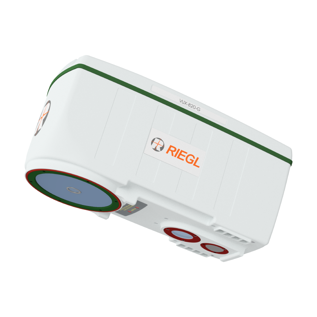
The RIEGL VUX-820-G is a topo-bathymetric airborne LiDAR system supplied as a fully integrated all-in package featuring an integrated RIEGL RiLOC-F inside inertial navigation system, integrated RGB camera, and proprietary software for generating georeferenced and refraction-corrected point clouds. Weighing 5.4 kg, it is designed for combined topographic and bathymetric UAV-based surveys and offers measurement rates up to 100 kHz with scanning speeds up to 50 scans/sec.
Overview
The RIEGL VUX-820-G is a small and lightweight topo-bathymetric airborne LiDAR system offered as a fully integrated “all-in” package solution. It includes an integrated RIEGL RiLOC-F inside inertial navigation system, an integrated RGB camera, and proprietary software licenses for generating georeferenced and refraction-corrected point clouds.
With a compact design and a weight of 5.4 kg (11.9 lbs), the system is well suited for UAV-based surveys. Additional features such as a status information display and status LEDs enhance system operation and handling.
Included Components
The RIEGL “All-in” Package includes:
- Compact LiDAR sensor providing up to 2.2 Secchi depth
- RIEGL RiLOC-F inside inertial navigation system
- Integrated RGB camera
- Proprietary software licenses for generating georeferenced and refraction-corrected point clouds
Main Features
- Lightweight design (5.4 kg / 11.9 lbs)
- Integrated RIEGL RiLOC-F inside inertial navigation system
- Integrated RGB camera
- Designed for combined topographic and bathymetric UAV-based surveys
- High accuracy ranging based on echo digitization and online waveform processing
- Multiple-target capability
- Concurrent comprehensive full waveform storage for all measurements
- Measurement rate of up to 100 kHz
- Scanning speed of up to 50 scans/sec
- Compact, lightweight, and robust housing
- Suitable for mounting on UAVs or integration into payload pods for crewed aircraft
- Status information display
- System parameterization via user interface
Main Applications
- Coastline and shallow water mapping
- River and water reservoir surveying
- Monitoring tasks in hydro engineering and harbor management
- Hydro archeology
Technical Specifications
| Specification | 5 kHz | 50 kHz | 100 kHz |
|---|---|---|---|
| Measurement Rate | 5 kHz | 50 kHz | 100 kHz |
| Maximum Water Depth Penetration (Secchi Depths) | 2.2 | 2.0 | 1.8 |
| Minimum Range | 20 m | 20 m | 20 m |
| Accuracy / Precision | 20 mm / 15 mm | 20 mm / 15 mm | 20 mm / 15 mm |
| Laser Wavelength | 532 nm (green) | 532 nm (green) | 532 nm (green) |
| Weight | 5.4 kg |
|---|
Related products
Reviews
There are no reviews yet.